
“A lake is the landscape’s most beautiful and expressive feature. It is Earth’s eye; looking into which the beholder measures the depth of his own nature.”
Henry David Thoreau
Because of its morphology, the main tourist route on the Dingle Peninsula is largely confined to its southern reaches, especially for coaches. The passengers therein are treated to splendid panoramas of mountains, islands and gleaming beaches. But Mr Thoreau would be disappointed as there are no lakes to measure the depth of his nature.
Yet, only 10km away on the northern side of the isthmus, within the boundaries of the Parish of Cloghane, there is a veritable congregation of lakes scattered attractively on the floor of the upper reaches of An Abha Mhor Valley or nestling in Cooms in the surrounding slopes and cliffs.


The latter will be of most interest to those walkers who stick to the lower routes as they are mainly found at high altitude except on the western seaboard where some can be located close to sea level as is the case in An Abha Mhor Valley. Cooms are one of the most dramatic features of glacial erosion.

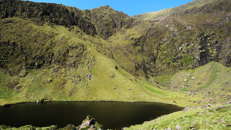
They are great circular hollows with cliffs up to 500m high. The Irish name is “Com” (pronounced “Koum”) and anglicised as “Coom” or “Coum”. The Scottish name “Corrie” has been creeping into usage here, mainly, I suspect, from the universities; a development of which I take a dim view.
One of the advantages of walking up this great valley with its aura of remoteness is that it is possible to enter a Coom which lies only a kilometre from the road. There is concrete bridge three kilometres from the start. Turn right just beyond it and a short walk will bring you to Loch an Mhonain which occupies the floor of the coom. It is indeed an impressive sight with 500m cliffs encircling its dark waters. The lower slopes are covered in scree chipped off the upper cliffs by frost action. The crest is dominated by the triangular peak on the Gearhan Ridge. Certainly, a place for contemplation.
Resuming the journey up the valley, the sense of isolation increases with the route being dominated by the Brandon Ridge immediately on your right and across the valley the cliffs of Sliabh Mhaca Re loom threateningly over the Conor Pass road which clings to its side. As you turn the corner into the head of the valley, the rising road gives you a view of the sparkling lakes which dot the boglands below.
The road ends at a cluster of abandoned farm houses but a broad track zig-zags on uphill. After a couple of hundred meters’ ascent veer off to the left on to the steep ground above Loch Dubh (the Black Lake). It belied its name on the day as it was as sparklingly blue under the high summer sun as the more aptly named Loch Geal, (the Bright Lake), which lies below it.
As I returned to Cloghane, I pondered if I had measured the depth of my nature but failed to come up with an answer, distracted as I was by the different perspectives that caught my eye.
The Cloghane Lake District, Co. Kerry
Map: O.S. Discovery Series. Sheet 70. 1:50,000.
Start and finish: A two-story house at the entrance to the Abha Mhor Valley. Grid Reference: 505 111
How to get there: Cloghane is at the western end of the R560 which runs along the north coast of the Dingle Peninsula.
Time: Five Hours.
Distance: 17 Km.
Total ascent: 200m.
Suitability: moderate.


