
Of all the elegant promontories that penetrate the periphery of the Atlantic Ocean on our southwest coast, perhaps the most iconic is the Old Head of Kinsale. It marks the boundary between that great body of water and the smaller Celtic Sea. It's lighthouse, its light flashing white every 10 seconds, has long been a signal to seafarers that they had arrived in more sheltered waters.
Long before walking for leisure became a popular activity, the bracing walk out to the Lighthouse was beloved of Corkonians. It was always assumed that it was commonage, but in fact was in private ownership and was sold for development as an upmarket golf course – to the eternal shame of Cork County Council, which could have purchased it to create a marine reserve.
This circumstance has led to “The Old Head” falling off the radar as a walking destination. This is a pity: the more interesting parts of the headland lie outside the security gates and surveillance cameras that now besmirch the antique ramparts.
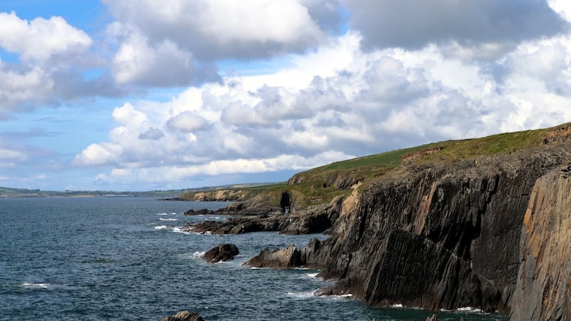
Start your walk along the clifftop path that runs east from the corner of Garrettstown beach. The rock structure of the cliffs consists of thin layers of shale, a softer version of slate. The tremendous forces that raised its strata from the horizontal to the perpendicular created numerous fissures in this soft rock.


These in turn were attacked by storm waves, creating vicious vertical reefs that would fillet the hull of any ship unfortunate enough to be grounded on them by the enormous waves that thunder onto this coastline in southeasterly gales.
The erosional process that is most dominant on such a fractured coast is the one whereby air is compressed into cracks, crevices and caves by onrushing water. The water retreats as quickly as it arrives and the compacted air expands explosively, further shattering the rock. The inner roofs of caves are most vulnerable and eventually collapse to create blowholes such as the large one on your path. Staring down into it, one can hear the sinister susurrations of the swash and backwash of the waves. Further along entire roofs have collapsed to create long narrow inlets called geos.
Returning to Garrettstown, cross the beach with its storm ridge forming a cobbled crown. A short path leads to Garrylucas or White Strand, at the end of which you may see a curious feature at low spring tides: layers of peat revealed, an indication of how rising post-glacial sea levels have inundated low-lying land over the past 5,000 years. It is a graphic portent of what lies ahead for coastal lowlands if global warming causes this process to continue.
A 3km uphill road walk leads to a delightful area without the guarded walls: 80m vertical cliffs fronted by great slivers of sea stacks, around which swirl hundreds of sea birds. The coastal panorama stretches from Seven Heads to the west and Ballycotton Island to the east; all of which can be enjoyed from the cafe in the Napoleonic tower on the high point of the headland, just above the beautifully designed Lusitania Memorial.
It is a walk of such diversity as to make a €1,000 four-ball seem somewhat banal.
OLD HEAD OF KINSALE
Co Cork
Map Ordnance Survey, Discovery Series. Sheet 87
Start and Finish Carpark at Garrettstown Beach, Grid Reference: 595 436
How to get there Take the R600 from Kinsale to Ballinspittle. Take the R604 from there to Garrettstown.
Time 3 hours
Distance 10km
Total Ascent 100m
Suitability Route is easy
Food and Accommodation Garrettstown, Ballinspittle, Kinsale


