
In the early 1990s, cycle paths were laid out along the Clontarf seafront. With a promenade already there, they were an easy enough addition, and mainly involved laying some new tarmac and a bit of white paint.
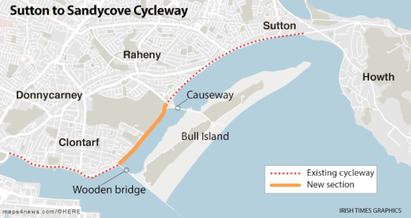
Except for one bit, a 2km section between the Wooden Bridge and Causeway Road, which was too narrow to accommodate a footpath and a cycle path, so was left alone.
Fast-forward a decade to 2002, when a continuous Dublin Bay cycle route called the S2S was proposed, to run along the seafront all the way from Sutton to Sandycove.
The idea was put forward by a voluntary group that included Michael Collins, a former president of the Royal Institute of the Architects of Ireland, and had a cost estimate of about €20 million.


In 2008 the council came up with an "ambitious" plan involving cable-stay bridging out over the lagoon at a cost of €14 million
With that not-too-frightening price tag, it found favour with the Fianna Fáil/PD Government. To get the ball rolling, Dublin City Council was asked to look at how it would bridge the 2km gap.
In 2008 it came up with an “ambitious” plan involving cable-stay bridging out over the lagoon at a cost of €14 million, but the council had missed the boat on ambitious plans by about a year, and the proposal was shelved.
Five years later it came up with a far more modest scheme. It would leave the lagoon alone and look at the roadway instead, reducing the width of the traffic lanes to accommodate cyclists. The work would be accomplished within a €5 million budget, which would also cover the cost of new drainage, road resurfacing and an upgrade of the flood defences by raising the sea wall.
All hell broke loose
Work began on the project in May 2015, and concentrated initially on the footpaths in front of houses and St Anne’s Park. After the summer, workers moved across the road to concentrate on the sea wall – and all hell broke lose.

Residents called for the council to immediately stop construction of the wall, claiming parts were several feet higher than agreed. The council said the wall, which was one metre above road level at its highest point, was necessary to protect against flooding. They considered using a glass wall, but that could have tripled the cost of the project to €15 million.
A flurry of reports followed, and in the end, the council agreed to lower the wall by 30cm and got on with construction of the path, which is now finished.
The offending section of wall is a stretch of half a kilometre opposite St Anne’s Park. It does not face any houses, and does not obscure the views of Dublin Bay for pedestrians and cyclists, only motorists.
Last month senior council engineer Chris Manzira said the council hoped to start work on lowering the wall later this year, but he said it would not be possible to reduce the height by 30cm for the entirety of the 470m section because this would make it so low in parts there would be a danger of walkers toppling over into the sea.
For the other side of the city, the National Transport Authority last October published a plan that would take cyclists from Sandymount to Blackrock. This area presents even greater difficulties than Clontarf, due to the Dart line and properties that have been built down to the sea.
The NTA proposed to get around these problems by digging a cycle and pedestrian underpass under the Merrion Gates and keeping cyclists on the not-very-pleasant Rock Road, where views of the sea will certainly be restricted. It plans to report on the public reaction to its plans in two months’ time.