A 300-year-old map detailing the gradual transfer of landownership from Catholics to Protestants went online today. The Down Survey of Ireland, which has been uploaded by the history department in Trinity College, was undertaken by the Cromwellian regime between 1656 and 1658.
The survey introduced Ireland to methods of modern mapping and created the first recognisable maps of the country. The survey was the first ever detailed mapping project on a national level and measured all estates that were forfeited by Catholic landowners.
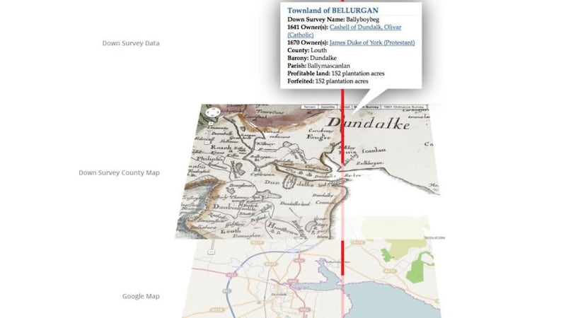
The original map collection was burned in fires in 1711 and in the Four Courts in 1922. It is made up of counties, baronies and parish maps. The details mark townland boundaries, churches, roads, bogs, rivers, woods and settlements.
The project to bring the map online was led by associate professor in modern history at TCD Dr Micheál Ó'Siochrú, along with a team of college historians who tracked down more than 2,000 copies of the original survey maps from libraries and archives in Ireland, Britain and France.
Mr Ó’Siochrú said the map’s website is an extraordinary and unique resource for early modern Irish history, which will transform our understanding of 17th century Ireland.
“Preliminary research based on on-going work suggests that our understanding of the scale and timing of the massive transfer of land from Catholic to Protestant landholders will need to be reassessed,” he said.
“The bringing together of this highly detailed map collection and related contemporaneous material with the aid of GIS technology allows us to reconstruct this period of Irish history. It will be of great interest to historians, genealogists, sociologists, engineers and anyone with an interest in Ireland, its past and its people.”
The website, downsurvey.tcd.ie, will allow users to explore 17th century Ireland in detail through use of GIS technology and through overlaying the Down Survey maps onto Ordnance Survey maps and Google maps. It will also map out murders and violent assaults reported during the 1641 rebellion.
Site visitors will also be able to search a database of 10,000 landowners.


