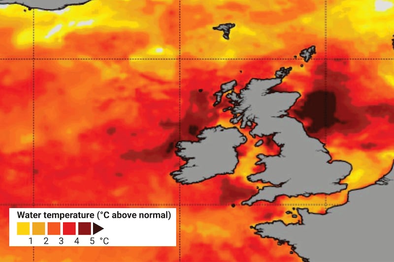
Sea temperatures that are “exceptional” for the time of year are driving the warmer than normal temperatures and recent thunderstorms, a Met Éireann climatologist has said.
The US National Oceanic and Atmospheric Administration (NOAA) has declared a Category 4 extreme event for the seas around the coasts of Ireland and Great Britain with temperatures between 4 and 5 degrees above normal in some places.
Met Éireann climatologist Paul Moore said sea temperatures are now what they should be in August when they reach their peak.
High sea temperatures are contributing to the warmer than average summer which is likely to continue, he says. It is also a significant factor, he believes, in the violent thunderstorms witnessed over the last couple of days, especially in Tralee where several premises were flooded in a very short period of time on Saturday.
READ MORE
“It adds extra energy into the atmosphere when we get low pressure as we have done in the last couple of days,” he explained.

“The extra moisture in the atmosphere adds extra energy so the thunderstorms we have had are likely to be increasing in intensity because of the increased sea temperatures around our coasts.”
Climate change is the main factor in current sea temperatures, combined with a number of other factors which have contributed to the anomalies.
The transition from La Niña to El Niño in the south Pacific has raised temperatures globally. The Atlantic multidecadal oscillation, a natural phenomenon where the ocean temperatures fluctuate, is in a positive phase which also means that ocean temperatures are higher than normal.
The Hunga Tonga undersea volcano which erupted in January 2022 in the south Pacific released billions of tonnes of water vapour, a type of greenhouse gas, into the atmosphere.
The synoptic (current) weather situation is also adding to the warmer oceans. The Azores High is to the north of Ireland this summer drawing up warmer waters from the south to Irish shores.
The position of the Azores high also means that the easterly airflow which draws millions of tonnes of sand particles from the Sahara desert over the Atlantic is weaker than normal. Sahara sand deflects sunlight and help keep the oceans cooler. Another potential coolant, the sulphide dioxide from transatlantic vessels, was banned in the early 2000s and no longer acts to mitigate ocean temperatures.
The rise in sea temperatures is reflected in values at bouys off the Irish coast. The M3 bouy off the southwest coast and the M4 bouy off the northwest coast are three and four degrees respectively higher than normal for the time of year.
[ How and why to sea swim: walk in slowly wetting your shoulders, if you likeOpens in new window ]
“Because of the background of global warming, the increases in temperature are ongoing all the time, but El Nino and the other factors are giving it an extra kick,” he said.
Mr Moore said the global climate models for the next three months are “very strongly in favour of above average temperatures in western Europe”.
“Higher sea temperatures usually mean higher temperatures over us. It also increases the risk of more violent thunderstorms.
“One of the predictions for our climate is for heavier and more intense rainfall events because there is more moisture in the atmosphere. There is a possibility of longer drought periods as well.”
Last month was the warmest May for the world’s oceans since record-keeping began in 1850, according to the National Oceanic and Atmospheric Administration.
The average ocean temperature throughout May was 0.85 degrees, higher than normal for the month.
For the planet as a whole May was the third warmest on record. North and South America had their warmest Mays on record.


