Every day this summer, thousands of tourists will leave the relative safety of the Cliffs of Moher Experience and enter the Cliffs of Moher Walking Trail.
This is the challenging and sometimes dangerous walking route near where a Belgian medical student fell to her death in May.
Many will enter the walking trail without even realising, and most will be ill-equipped for the potentially dangerous challenges it presents.
The Cliffs of Moher trail is classified as a grade 5 walking route by Sport Ireland, the most dangerous designation possible.


The official guide for the trail describes the route as “dangerous” and suggests that walkers have “a high level of fitness” and bring hiking boots, a supply of food and other essential safety equipment.
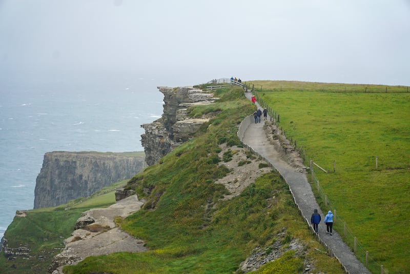
A walk south along this trail towards Hags Head reveals some of the most iconic views of the 700ft-high cliff, with a narrow but well-marked pathway guiding tourists on a route parallel to the edge.
However, tourists regularly leave the official trail and venture to the cliff edge itself, especially when the route is crowded or when taking photographs.
This week, the agency responsible for managing the trail, Clare Local Development Company (CLDC), conceded that the current management plan for the trail “isn’t adequate” and “something has to change”.
CLDC, Clare County Council, Fáilte Ireland and the Department of Community and Rural Affairs are working to create a new strategic plan for the trail.
“Safety is always at the forefront of our mind, 100 per cent. The key message that we are trying to put out there to people is that, if you stay on the official trail, you are safe,” says Eoin Hogan of CLDC.
In the incident involving the death of the Belgian student, group members were walking off the official trail.
“Two groups met each other, and one tried to go around the other. If they had stayed on the official trail, this wouldn’t have happened,” says Hogan.
He says it is a challenge to maintain the trail as it was designed for “a certain number of users each year”.
“But in sections close to the centre [the Cliffs of Moher Experience], you are getting 500,000 people each year. The footfall is much higher than expected,” he said.
“You have a trail pointing out into the Atlantic that gets hit by every storm that comes through. The trail just wasn’t constructed for these numbers.”
The Co Clare clifftop walking trail is about 18km of cliff edge, running from Liscannor in the south to Doolin in the north.
Close to its centre is the Cliffs of Moher Experience, an 800m long section of cordoned-off and marshalled cliff edge, which is expected to attract more than 1.5 million tourists this year.
When the walking trail was officially opened in 2012, it was designed to cater for tens of thousands of users. However, as there is unrestricted access between the trail and the Cliffs of Moher Experience, close to 500,000 tourists now walk sections of the trail annually.
The trail itself is owned by 38 local farmers, who each receive a payment under the National Walks Scheme for the use of their land. In recent years, the farmers also receive a top-up payment of €1,000 a year from Clare County Council to compensate them for the unexpectedly high numbers of people using the trail.
[ Revenue at Cliffs of Moher climbs to €13.8mOpens in new window ]
Safety and essential maintenance of the trail is an ongoing challenge, with flooding, mudslides and other hazards common occurrences, especially during winter.
Over the past year, Clare County Council has upgraded about 2km of the trail to the north and south of the Cliffs of Moher Experience, creating a safer walking route for visitors.
However, many tourists choose to leave this route, with well-worn tracks visible along the very edge of the cliff face.
Pat Sweeney, a local walking guide and one of the 38 farmers whose land is part of the trail, believes that while safety and the standard of maintenance have improved in recent years, more needs to be done to make the route fully safe.
“These days, I think that visitors are relatively safe on the upgraded areas, to the north and south of the visitor’s centre. But when you go past that, it’s different,” he says.
“The majority of the visitors who come there are not prepared to go for a hike. They don’t have the right gear, they don’t have the right footwear for a start. It’s a simple thing, but the right footwear makes an awful difference.”

A flood or mudslide needs to be dealt with immediately, he says, given the number of people walking the trail every day, but in the past it might have taken a month or two to rectify.
“For the first few years the trail wasn’t under pressure, because people were only starting to get to know about it and it was in good condition. But it’s a very exposed trail and as people got to know about it and the numbers increased so much, it started to deteriorate,” he says.
One of the key dangers of the trail is tourists entering the walking route without realising they are leaving the safety of the main tourist centre, despite signs warning of the dangers ahead.
“Our responsibility is for the 800m of safe pathways and safe viewing areas where people can come and view the cliffs,” says Geraldine Enright, manager of the Cliffs of Moher Experience.
“If anyone goes out over the wall, they are asked to come back. Our customer service agents are trained for proactive guiding and visitor safety. Anyone who becomes compromised in any way, there will be staff intervention.”
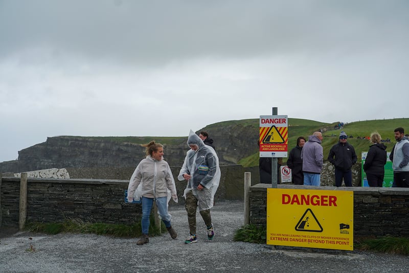
She says signs at either end, where the Cliffs of Moher Experience meets the general walk, inform the public they are leaving the site and“moving on to a “high-difficulty walking trail”.
Negotiations between CLDC, Clare County Council, Fáilte Ireland and the Department of Community and Rural Affairs continue in relation to the future management of the trail and hopes are high that a framework can be approved before the end of the year.
“All the agencies have come together and realise that the way the trail is being managed at the moment isn’t adequate for the numbers that we have using it,” said Hogan.
Landowners have been contacted.
“Communication is in a good place in general. All the people involved agree that we can’t keep going the way we are and something has to change in terms of the management of the trail and the reimbursement of farmers for the use of their land,” he said.
Clare County Council has just been granted €500,000 to fund the development of a further 2.6km of the trail to the north and south of the main visitor’s centre. At present, it is not fully clear who is responsible for essential maintenance issues on the upgraded sections of the trail.
A spokesperson for Clare County Council said that CLDC was “responsible for the overall management and administration” of the trail. However, the company says the council is responsible for the upgraded sections, at least on an interim basis.
“Because of the way the funding works, the council are the body which can apply for the upgrades to the trail. The council are managing that, and they are engaging with the local landowners to go in and do that work,” said Hogan.
He says that for now, the council is maintaining those sections but the long-decision on who will carry out this work will be part of the strategy that should be completed by the end of the year.
“So at the end of the year we will know where we are going,” he said.
Sweeney says the farmers are currently “in limbo” between the two organisations, the council and the development company.
“It might be a thing that in a few years’ time, Clare County Council might come in and take over the whole trail from Liscannor to Doolin,” he says.
“We just don’t know.”
- Sign up for push alerts and have the best news, analysis and comment delivered directly to your phone
- Join The Irish Times on WhatsApp and stay up to date
- Listen to our Inside Politics podcast for the best political chat and analysis