"It was the kind of moon that I would want to
send back to my ancestors and gift to my descendants
so they know that I too, have been bruised... by beauty."
Sanober Khan
Mt Hilary (391m) is an outlier of the Boggeragh Mountains. It is a stand-alone hill in the great lowland of the Blackwater Valley. If it had remained unforested it would give all-around views across the patterned floor of the valley to the Ballyhoura and Galtee Mountains, and to the south and west a dramatic panorama of the great ramparts of the Armorican Fold Mountains, stretching from the Boggeraghs away west into the mists of the Kerry massif.
But the vistas are not entirely lost as there are views to be glimpsed through the trees, especially at the summit where there is a clear prospect to the south and south west. The hill is clothed in Pine, Spruce and Larch with the occasional Sequoia Tree, a rare species in this part of the world. There is also a sufficiency of Rhododendron to add glorious colour in late spring.
Mt Hilary is beloved of walkers as, for the most part the three Looped Walks follow broad forest tracks where the hard core has sunk into the soft ground to make a nice even surface. However, the last section of the track to the summit is rutted and wet and you’d need to be agile to avoid the small pools or else plough comfortably along in boots and gaiters. The Red Loop, which is well marked, covers 10 kilometres with an ascent of 290m.


I hadn’t come to “Loop a Loop” on this occasion. I had another agenda. Mt Hilary is a safe spot for a hill walk at night, so I had decided to plan a walk which would involve being on the summit at sunset.
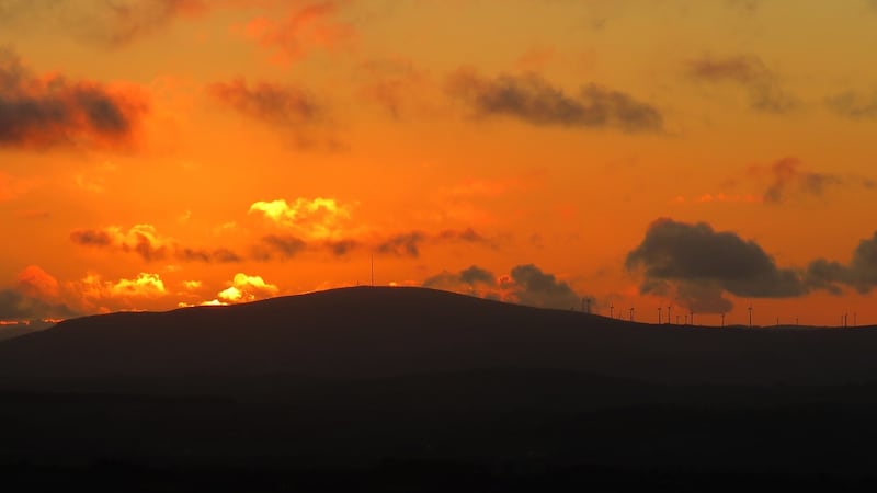
Instead of going to the Trail Head at the Wood’s entrance (W430 972), I parked at a forest barrier on the west side of the hill and followed a zig-zag path on to the westerly curve in the Red Route. From there it was a straight walk to the summit in the gathering dusk. I sat watching the outline of the Boggeraghs deepen to black as the sky morphed from blue into a deep orange except where the sun, having slipped below the ridge sent up flares of gold. As this display of vivid colours slowly faded, the landscape was bathed in the silvery light of a waxing gibbous moon.
The walk down was entirely magical. I had no need of my torch as the moonlight was so strong in the clear night air that not only did it make the track visible, it threw my shadow on to it. The bare branches of the deciduous trees that lined the track were lit into ghostly patterns and occasionally a shaft of moonlight struck the ground through gaps in the dense plantation. To compliment the natural light, the black valley below me was slowly sprinkled with the lights from a myriad of farm houses.
It took a while to gather my senses to begin the drive home.
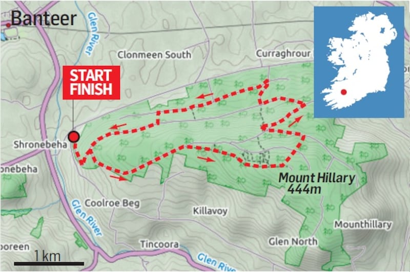
Map: Ordnance Survey, Discovery Series, Sheet 79 & 80. Downloadable Map on Website.
Start & Finish: An entrance at the western end of the forest. Grid Reference: 393 961.
How to get there: Take the first left on the R579, 2km south of Banteer. After 400m take a sharp left at the fork. The entrance is about 150m along this road.
Time: 2.5 Hours.
Distance: 6km.
Ascent: 290m.
Suitability: Easy. Good Footwear.