
Several years ago, while out on the roads of Ireland, we met Anja, a travelling harper. She explained to us that the difference between a harper and a harpist is that harpists perform concerts in spaces dedicated to music, while a harper travels the countryside with their harp on their back, meeting people and playing wherever opportunity presents itself.
A harper is folky, has no schedule, and isn’t a fan of targets or deadlines. We would consider ourselves more cyclers than cyclists.
We don’t own coloured Lycra, we’ve never competed in a cycling race, and we don’t usually pay attention to time or the number of metres we’ve climbed in a day. When we’re on our bikes, we’re more engrossed in the pleasure of the journey than in the destination.
When our hero, intrepid cycler and travel writer Dervla Murphy, set out from Lismore, Co Waterford, in 1963 to pedal to India, she did so on a basic bicycle with no gears, in a sensible pair of shoes, with her pants tucked into her socks. What O’Carolan is to the harp, Murphy is to the bicycle.
Eurovision 2025 second semi-final live updates: Ireland’s Emmy is knocked out before grand final

Fred and Rose West: A British Horror Story review – A chilling gaze into a monstrous, soulless void

First Look: Mission: Impossible – The Final Reckoning: Tom Cruise gets all sentimental amid some suave mayhem

In that spirit, we have crossed 17 international borders together as cyclers. Next spring we set off on our biggest journey yet: we’re cycling around the world. We’ve been planning this trip for four years, and have renovated and sold two converted double-decker bus tiny homes to fund the adventure, naming one Dervla after our hero.
This summer we’re revisiting our favourite spins in Ireland before setting off on the cycle of a lifetime next spring. Here we’ve selected five routes with something for all levels of ability. You don’t need a lot of gear, just a functioning bicycle, a packed lunch, a raincoat with a bottle of sunscreen in the pocket, and your towel and togs. So tuck your pants into your socks, swing your leg over your bike, and away we go.
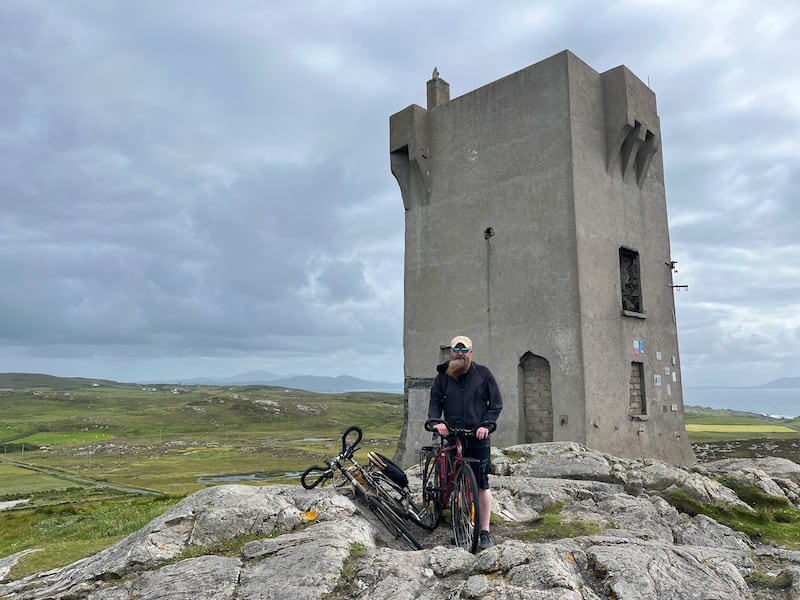
Malin Northern Loop
Starting a cycle at Culdaff on the Inishowen peninsula in Co Donegal gives all the satisfaction of reaching Ireland’s most northerly point in a handy but hilly 51km.
Distance: 51km
Elevation: 534m
Diversions: A hilly detour to Ross Head and the historic second World War “Eire 81″ sign adds an extra 5.6km, or work in part or all of the Inishowen 100 for a bigger challenge.
Directions: Park at Culdaff Beach. Through Culdaff Village, turn right for Glengad. After Portaleen Pier, turn right at a Y junction signposted 15km to Malin Head. Turn right at the junction at Mullins Shop at Bree Lower, signposted for Malin Beg. 1.85km later, take a short, steep detour down to explore the Wee House of Malin in a beautiful rocky bay. Rejoin the road towards Malin Head turning left on to the R242 and follow it to Malin Head. After Malin Head, go back along the R242 and head to Umgall, following the R242. At Malin village, go straight through the junction on the R243 and follow the signs for Culdaff.
Ellie writes:
Despite the dramatic beauty of Malin Head itself, my favourite stretch of this cycle is from Umgall to the Moss Road on the way into Malin village. An exhilarating downhill stretch has you whizzing past craggy outcrops, with views of softly rolling grassy dunes and the dazzling golden sands of Five Finger Strand behind you.
Because of prevailing winds, you’ll likely have a headwind on your way out to Malin Head and this, like the old Irish blessing, will be at your back on your return once you’ve tackled the hillier sections of the route. This means it’s worth keeping an eye on the weather when planning this cycle. It would not be fun in high winds.
Culdaff beach is a great place to start and finish this loop: it has coffee stalls, toilets, and even mobile saunas that would be great for tired post-cycle muscles. Bring togs for a dip at the end of your cycle.
Mark writes:
It’s not unusual to have the hind legs talked off you wherever you stop along the road on our island, but there’s an added edge to it in Donegal. It feels like they are genuinely glad to see you. Ellie’s theory is that some of the farmers are keen to add more depth to the gene pool, but I reckon the people we encounter up there are just a couple of degrees friendlier than most other counties.
We’ve cycled this route three times and it was only on this spin we discovered that the Wee House of Malin isn’t a house, but a church with a hermit’s cave and well behind it. I have a theory about the fractal geography of Ireland: the closer you look, the more there is to see. It would take several lifetimes to cycle every laneway, walk every boreen and climb every hill. There is always something new to discover. The panoramic view that opens up as you make the descent to Malin Beg is my favourite part of this route.
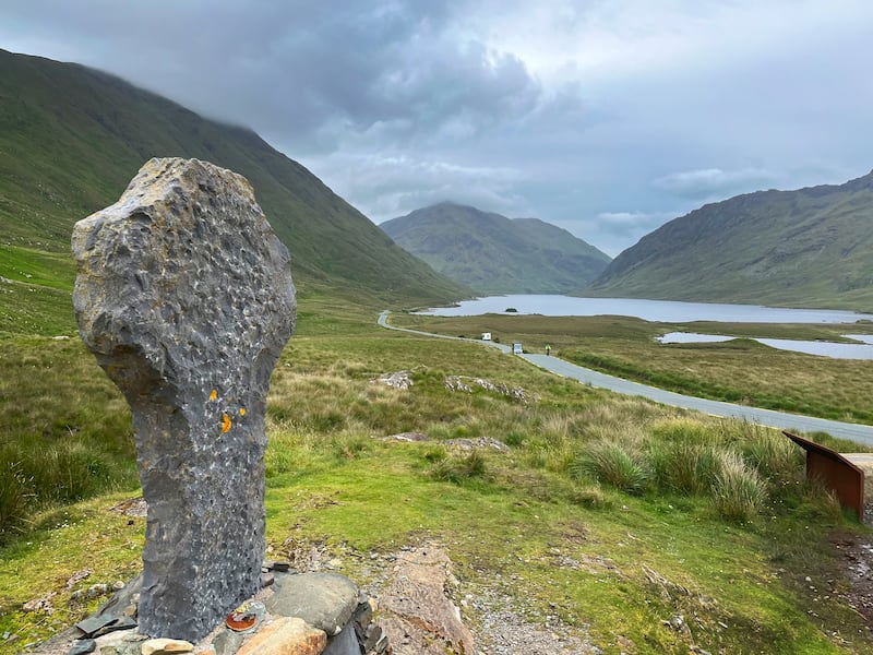
Doo Lough Loop
Over the enchanting Sheeffry Pass, past Doo Lough Famine memorial and under the shadow of Croagh Patrick, this 64km loop in Co Mayo is breathtakingly beautiful.
Distance: 64km
Elevation: 421m
Diversions: Starting in Westport instead of Aughavale cemetery adds an extra 7km to the loop. Turning left on to the R378 at Cregganbaun after Doo Lough adds an extra 14km and brings you past the extraordinary Clapper Bridge of Bunlahinch. Staying on the N59 at Liscarney to take in Leenane, the spectacular Aasleagh Falls, Killary Fjord and Delphi adds an extra 10km.
Directions: Park at Aughavale Cemetery, 3km outside Westport towards Louisburgh. Take the immediate left fork at the cemetery, signposted with a cycleway sign for Killary Harbour. Follow the Killary cycle signs until you reach Brackloon woods. At a signpost for Owenwee Kennels, go straight on to join the N59 for 1.7km before turning right on to the L1824 at the sign for Drummin and the Sheeffry Pass. The L1824 emerges on to the R335 at Doo Lough. Turn right here. Stay on the R335 all the way through Louisburgh towards Westport and Aughavale.
Mark writes:
The stretch up and over Sheeffry Pass and down alongside Doo Lough isn’t just beautiful to look at. The honeysuckle was in bloom the last time we cycled here, and at the bottom of the mountain the sweet smell was mixed with turf smoke from fires still being lit in midsummer. All the way down the mountain you’re flanked by a river that gurgles, plunges, and splashes its way down the hillside with you. You don’t get to hear and smell this route by car.
Doo Lough, the black lake, is brooding, dramatic and historically significant. In March 1849, 600 starving people walked 12 miles in poor weather from Louisburgh to Delphi House to petition their landlord, the Poor Law Inspector, and a member of the Board of Guardians who were all lodging there. When the starving people arrived, the men they hoped would help them were at lunch, so they had to wait. When the crowd were eventually seen, they were sent back to Louisburgh empty-handed. Some reports say that 400 people died of starvation while walking this road. Stories are told of corpses found at the side of the road with grass in their mouths. For all its beauty, there is a palpable solemnity to this stretch.
Ellie writes:
This loop is an absolute winner for me. The variety of scenery, from lush hilly woodland and rocky mountain streams, to barren bogs scattered with twin white tufts of bog cotton and sheep, is just breathtaking. The Sheeffry pass has all the rewards of any mountain pass but is surprisingly doable, with no punishing switchbacks. Views of Tawnyard Lough from the rest stop on the L1824 on the way down are out of this world on a clear summer’s day.
There’s plenty of heritage interest too, with an obligatory stop at Doo Lough famine memorial, the hulking mass of Croagh Patrick with its endless succession of pilgrims, and the well-signposted Clew Bay Archaeological Trail all around. The only downside might be the 12km stretch alongside the R335 from Louisburgh to Murrisk, where traffic can be heavy and fast. Almost all of the rest of the route is on very quiet laneways and from Murrisk, an incomplete greenway brings you the last 6km back to the turning to Aughavale.
Carrick-on-Suir Blueway
This linear paved path following the river Suir between Carrick-on-Suir and Clonmel in Co Tipperary is flat and entirely off-road, making it an ideal gentle jaunt.
Distance: 40km
Elevation: 19m
Diversions: For a longer and more challenging route, leave the Blueway in Kilsheelan and follow the R706 to a T-junction where the right turn takes you to Killusty. From Killusty there’s a loop that takes you on a 42km circuit of the foothills of Slievenamon, through Kilcash and back to Kilsheelan.
Directions: Find parking near Seán Healy Park in Carrick-on-Suir. As you face the park with the river in front of you, the entrance to the Blueway is in the right-hand corner. From here, the paved path follows the river completely off-road all the way to Clonmel.
Mark writes:
We’re blessed with some wonderful greenways around the country. The Copper Coast road from Tramore to Dungarvan and back along the Greenway to Waterford is among my favourite cycles anywhere in the world, but there is something about the understated gentleness of the Carrick-on-Suir Blueway, winding its way along with the river Suir, that merits a mention.
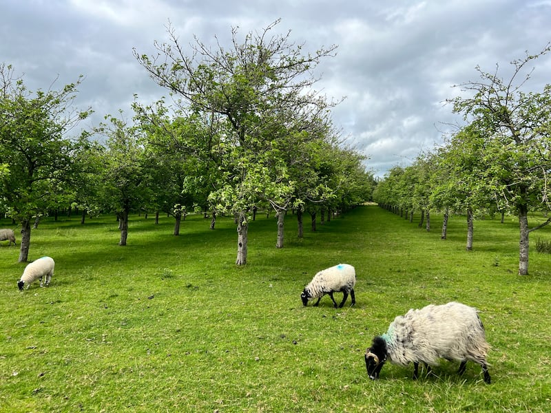
You’ll see fish jumping, herons hunting, and cormorants drying their wings. If you look very closely you can catch the Technicolor flash of a kingfisher or the sleek oily slink of a swimming otter, but be careful: Tipperary otters are ornery. The route passes the Bulmers orchards, where possibly the happiest sheep in Ireland graze beneath the apple trees.
There’s a nice contrast between some of the colourful ramshackle fishermen’s huts along the river and the grand castles at either side of Kilsheelan. Keep an eye out for Gurteen Castle on the other side of the river after Kilsheelan bridge.
Ellie writes:
An rud is annamh is álainn: what’s rare is wonderful. Not only is it rare to get to experience 40km of gentle cycling off-road alongside the tranquillity of one of Ireland’s most majestic rivers, but the Suir Blueway is also rare because it’s a seasonal joy: while the river is in flood in winter and spring, this Blueway is often not passable, so this is definitely one to do on a summer’s evening with the flies doing their eternal dance over the water and the trout rising.
Factor in the silence, the wildlife, the undulating fields of ripening grain, and the fact that you don’t have to navigate so much as a single junction with cars, and really this cycle is so relaxing that it can seem like a meditation.
It’s very safe for children of any age and even the littlest legs won’t struggle on the flat, but families might like to shorten it by starting at Kilsheelan or doing a short stretch starting from either Clonmel or Carrick.
The Healy and Caha Loop
Sweeping vistas of Bantry Bay and Kenmare make this mountainous cycle in counties Cork and Kerry as rewarding as it is challenging.
Distance: 80km
Elevation: 922m
Diversions: Taking a right turn from the R571 about 6km before Kenmare instead of taking the N71 right outside Kenmare shaves 7km off the distance and takes you past the picturesque Dromoghty Lough, but it adds another climb.
Directions: Park in Glengarriff and follow the sign for Castletownbere and the Ring of Beara. After Adrigole, turn right for the Healy Pass. At the Sibín Bridge in Lauragh, turn right on to the R571. Follow the R571 until just before Kenmare where you make a right on to the N71 which you follow up the Caha Pass and back to your starting point.
Ellie writes:
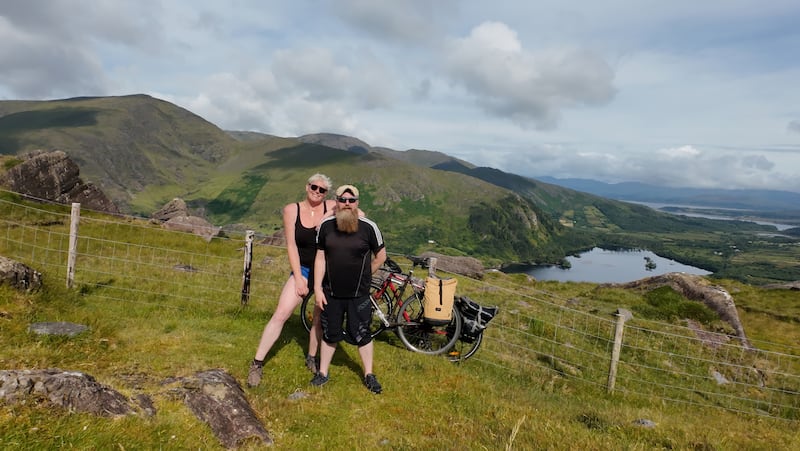
This spectacular cycle is my all-time favourite. The most gobsmackingly beautiful view on this mountainous cycle is from the top of the Healy Pass looking down into the Kingdom over Glanmore Lake.
We’ve done this loop in both directions, and I definitely prefer tackling the steeper Healy Pass with its heart-pounding switchbacks first and leaving the Caha Pass, a gentler but bigger and longer climb, until last. Once you make it through the last of four tunnels hewn from the mountainside, you crest the hill and then there’s a glorious final 10km downhill, with views of Barley Lake and Bantry Bay, to your destination of Glengarriff.
Watch out for the sneaky extra climb after the Healy Pass: between Lauragh and Kenmare, there’s another elevation that isn’t as high as the others but still takes effort. This cycle is challenging but can be taken slowly and, a bit like life, every inch of struggle to reach those peaks comes with equal rewards.
Mark writes:
We have history with this route. This is one of the first cycles that Ellie and myself did when we first met 10 years ago. About halfway up the Healy Pass that first time, I wheezed out the code to my mobile phone because I was pretty sure that I was going to have a heart attack and my next of kin would need to come get me. I didn’t, and in the intervening years I’ve surprisingly started enjoying the mountain climbs. Are they a metaphor for life, or does the endorphin rush of cycling up and down mountains scratch the itch of an aged jaded raver?
The Healy Pass does it for me. Classic Irish scenery, with switchbacks all the way up to the cross at the top. We sang Whiskey in the Jar as we pedalled up the mountainside for the Cork and Kerry reference on our most recent spin here, and for the benefit of the two Japanese touring cyclists who passed us at pace on the way up, but we all stopped to share broad grins and enthusiastic babble when we cleared the summit and looked down over The Kingdom. You can’t beat the endorphins, in fairness.

The Nore and Barrow loop
Two rivers, three counties, four scenic villages and a whole heap of postcard-perfect scenery.
Distance: 60km
Elevation: 610m
Diversions: A 5km round trip from Thomastown out the R448 and back will allow you to take in the ruins of 12th-century Jerpoint Abbey.
Directions: Park in Thomastown and take the R700 through Inistioge and over Garrett Bridge outside New Ross. Turn left after the bridge and then left again on to the R729 signposted for St Mullins. Take a left at St Brendan’s church. At St Mullins, turn right up the river bank, well signposted as part of the Barrow Way. From Graiguenamanagh take the R703 back to Thomastown.
Ellie writes:
A lot of our favourite cycles are in rugged wilderness, so this loop, mostly through gently rolling farmland with some woods, makes for variety. Inistioge and St Mullins are both great stopping-off points and St Mullins is an amazing historical site that is definitely worth exploring.
The Gobán Saor, a mysterious travelling stonemason about whom many legends exist, is said to have built the original chapel where St Molaing settled and a statue pays tribute to the legend of the Mad Sweeney, an ancient king of the Dalriada who lost his mind in battle and wandered Ireland before meeting his demise in St Mullins.
Eight kilometres along the Barrow Way between St Mullins and Graiguenamanagh sees you sharing an unpaved but level path with walkers and passing some phenomenally gorgeous lockhouses. The presence of cyclists on this stretch has stoked controversy in the past, with locals campaigning against the paving of this former tow path, so good manners, giving way to walkers and not zooming up behind them or hogging the path would be the classy approach.
At Graiguenamanagh there’s a swimming spot complete with lifeguards in summer, and plenty of riverbank for picnics.
Mark writes:
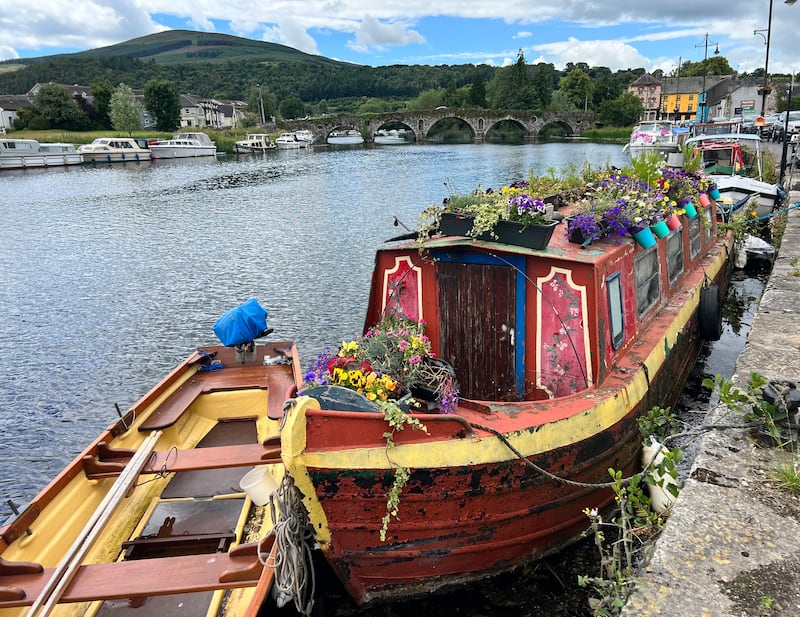
This is the prettiest of the five spins. The towns along this route are what misty-eyed emigrants conjure up when they dream of the auld sod. Inistioge is so photogenic that it has its own IMDB page.
It’s the spin along the old towpath from St Mullins to Graiguenmanagh that floats my boat. This is not a cycle path; it’s a grass path that follows the old industrial towpath that was once well worn by horses pulling barges and narrowboats up and down this stretch of the Barrow. As it stands, walkers and cyclers coexist in a state of compromise on either side of this verdant and bumpy byway. Whether worn by legs or wheels, this gentrified version of the towpath has come a long way from its industrial beginnings of horse dung, coal slack, cut-throat river bandits, and rats. It’s beautiful now, but it was probably more exciting then.
The going gets muddy and slippery by bike once the ground gets wet, best avoided at the wettest times of year, but as a well-seasoned Cork woman told us in the woods above Glengarriff, “if we let a bit of rain stop us doing things in Ireland, we’d be f**ked.” Well said, madam.
You can follow Ellie’s and Mark’s cycling adventures at spokeyokes.substack.com


