It has been a frustrating summer in Ireland, and much of north-western Europe, with strings of depressions passing over or close to us, bringing Atlantic cloud and rain across Ireland in copious amounts. A brief heatwave in June was essentially the only settled spell before the record breaking rainfall of July and the ongoing continuation of unsettled conditions into mid August at least.
Particularly after the glorious summer of 2022, expectations of a repeat were high, only to be dashed as conditions radically switched around the end of June.
Climatologists have noted a tendency for such a return to westerly conditions to occur in late June/early July, and some have suggested this is possibly linked to the warming up of continental Europe which subsequently draws in Atlantic air rather like a giant sea-breeze effect. Indeed they have coined the term “European Monsoon” to describe the phenomenon.
But it is not really akin to the Asian monsoon and only sporadically occurs to ruin the Irish summer. July 2023 will be remembered in Ireland however as the wettest July on record.
How a hotter world is affecting Ireland in five graphics

Why international firm Corio withdrew from plans for Sceirde Rocks wind farm off Connemara’s coast

Take fewer flights or switch to an EV – what’s the best way to reduce my carbon emissions?

Meet Romulus and Remus, first of their kind for 10,000 years. Sort of

Some of the events of summer 2023 would be unthinkable in the absence of greenhouse gas loading of the atmosphere
All the while we were looking out our windows at the rain, southern Europe was baking in temperatures in the 40s, as were the south-western United States, China and Japan. The excess death toll from these heatwaves in Europe alone is almost certain to top the 61,000 from last year’s events. New maximum temperature records were set in several locations across the Mediterranean, while in China the mercury soared to a new national record of 52.2 degrees on July 16th.
What was striking about these events was that they occurred simultaneously across the northern hemisphere and proved very persistent. Phoenix, Arizona, for example, recorded 31 straight days of temperatures over 43 degrees. Across the northern hemisphere the atmospheric circulation seemed stuck in position and effectively stationary, bringing heat, drought and fires to some, and cool weather and floods to others, as residents of Dublin, Wexford, Kerry and Donegal will testify.
In explaining the events of summer 2023, the role of the jetstreams is the short-term key. These fast-moving meandering westerly winds at heights of 10km are instrumental in encouraging the formation of depressions and anticyclones down at the surface. Typically they circle the northern hemisphere from west to east at speeds of 150-225km/h, encouraging weather systems at the surface to form and then move on.
But on some occasions they exhibit large meanders, with amplitudes of several thousand kilometres. An imperfect analogy is that of a slow-moving river, meandering widely across a low lying area. In these circumstances, the progression of weather systems, especially anticyclones, slow down and can become stationary for long periods. This is what is termed blocking.
When a small number of blocks occur, the jet streams can wriggle on, and while conditions, such as we had in Ireland during our June heatwave may last for a week or two, normal progression of weather systems may ensue. However, with a larger number of waves, a more pronounced blocking pattern can be established around the whole northern hemisphere.
One of the most favourable blocking arrangements is when five big meanders occur in the jet streams simultaneously. This provides a very effective lock. To return to the river analogy, this is rather like a river negotiating five big boulders in its flow by settling into a route between them which may persist until upstream conditions change sufficiently to dislodge the flow pattern.
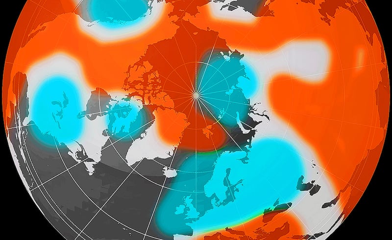
The chart shows atmospheric pressure departures from normal high up in the atmosphere in mid July of this year, looking down over the North Pole. There are five circular patterns where the pressure was anomalously low, including Ireland and much of northern Europe. This is where low pressure systems were dominant. Five big wave meanders are apparent.
In each case, south of these, stubborn anticyclones can be seen across the Mediterranean, Central Asia, China, Japan and the US – the locations of the deadly summer 2023 heatwaves. The five loops in the jet streams effectively stalled changes in the weather pattern across the northern hemisphere for over a month.
The big question is what climate change is doing to enhance or reduce the “loopiness” of the jet stream?
Although the answers to this are complex, there are some aspects that climate scientists are clear on:
1. The jet streams are strong when the temperature difference between the tropics and the Arctic is large. When it is small, the jet streams become more sluggish and meander more. The waves become more pronounced.
2. The Arctic is currently warming almost four times as quickly as the planet as a whole. The temperature difference between the tropics and the Arctic has reduced. The link with the first point above is clear.
The risks of a “five-wave summer” would seem to be on the upside. Apart from the problems simultaneous extremes in key areas of the world may pose for human health, biodiversity and food production, among other multiple potential adverse impacts, the realisation that climate breakdown may be under way should propel decision makers into taking the urgent action that the climate emergency demands. It is not enough to merely identify a climate change fingerprint in heatwave events.
Some of the events of summer 2023 would be unthinkable in the absence of greenhouse gas loading of the atmosphere. Countries not taking the hard decisions to reduce their emissions radically can no longer simply be labelled as “laggards”.
Rather they are complicit actors in the furtherance of a dystopian future.
John Sweeney is Emeritus Professor of Geography, Maynooth University